Coal Train Passing
One of the banes of my current existence is a long commute from Annapolis to Washington. There are some advantages of a daily opportunity to see a lot of people and pass by a lot of examples of how people live and work. I also am blessed by being able to pass by some inspirational sites on a daily basis – the Capitol, the National Archives, the Jefferson Memorial, the Washington Monument, and various sections of the Smithsonian Museum.
I also get inspiration from sights that many people simply filter out. For example, about half of my commute parallels a rail line that provides a route from coal mine areas to coal fired power plants. Many days, I see miles and miles of topless cars piled high with coal on their way to the power plants that provide much of the electricity for our nation’s capital. I sometimes play a game to keep amused while traveling past the trains – I use my odometer to try to estimate just how long they are. The longest one I have computed was more than 4 miles long.
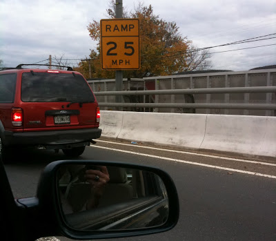
I have often thought of snapping a few photos to add to my collection of competitive fuel sources. A couple of weeks ago, I happened to be stuck on the exit ramp from the Southeast-Southwest freeway onto Pennsylvania Ave. and had my phone on the seat next to me. I pulled it out and snapped the below. It is not a terrific picture, but it is just a part of a train that was moving past when I arrived in the line of traffic and was still passing when I finally broke free more than 7 minutes later.

To see the coal train, look past the ramp speed limit sign and the railing – you should be able to pick out the cars with their mounded cargo. One thing that the photo shows is how coal transportation companies cut their costs to the bone by not even bothering to cover the cargo. It leaves a trail of dust and debris along the track, but since coal is so “cheap” no one seems to care – other than those who live near the rails.

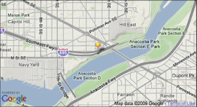
Here is a little map to show just where the photo was taken. Someday, I am going to trace the rail line using one of those great mapping programs that are now available to see if I can find the destination power station. I used to think I knew were the trains were headed, but then found out that the Benning Road power station that is right along my commuting route is an oil burner that only runs a few hours per year when the weather is really bad or when other plants are not available due to unplanned outages.
